Captain James Lowe
USCG 200 Ton Licensed Master
(727) 236-1385

Okeechobee Waterway

Captain James Lowe's yacht delivery services can be particularly beneficial for vessel owners who are unfamiliar with the Okeechobee Waterway, A cross Florida waterway traversing South Florida , incorporating lakes, rivers, and manmade canals there are five lock and dam systems along the route that can present challenges for inexperienced boaters. As an experienced and licensed captain, James Lowe can help navigate these obstacles with ease and ensure a safe and successful journey. Whether you need assistance for a long voyage or crew assistance, Captain James Lowe has the expertise to guide you through the Okeechobee Waterway and make your journey a smooth one.
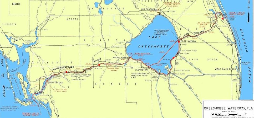
The Okeechobee Waterway is a 154-mile inland waterway that crosses the lower peninsula of Florida, connecting the Atlantic Ocean in Stuart, Florida, to the Gulf of Mexico in Cape Coral, Florida. It was built by the Army Corps of Engineers and utilizes the Caloosahatchee River, Lake Okeechobee, and the St. Lucie Canal. The waterway is a navigable route that provides a safe and efficient way for vessels to cross Florida by water, saving time and distance compared to traveling around the peninsula by sea.
The Okeechobee Waterway is comprised of five navigation locks and dams along its route, including the St. Lucie Lock & Dam, Port Mayaca Lock & Dam, Moore Haven now (Julian Keen, Jr.) Lock & Dam , Ortona Lock & Dam, and WP Franklin Lock & Dam. These locks and dams provide essential infrastructure for safe and efficient navigation along the waterway, allowing vessels to transit between different water levels and regulate the flow of water in the canal. Whether you're a commercial vessel operator or a recreational boater, the Okeechobee Waterway is an excellent option for crossing Florida by water, providing a unique and scenic experience while also saving time and distance.
If your going into Clewiston, there's an extra lock that's usually open at the entrance of Clewiston, FL. However, this route entails a sharp turn into a narrow lock or flood gate. Nonetheless, Clewiston serves as an excellent fuel stop, with its marina and tiki bar restaurant providing a relaxing and enjoyable atmosphere. It's situated at the fork in Route 1 and Route 2, offering you the opportunity to take a break from your journey and explore the area. Additionally, it's worth noting that the Okeechobee Waterway (OWW) is open to vessel traffic throughout the year, giving you the flexibility to plan your trip at your convenience.
From East to West along the Okeechobee waterway the locks are: St Lucie Lock and Dam near Stuart FL, Port Mayaca Lock and Dam near Canal Point FL, Moore Haven Lock and Dam at Moore Haven FL, Ortona Lock and Dam east of LaBelle FL, the Franklin Lock and Dam east of Fort Myers FL.
Notice to Mariners:
Hours of operation at all five locks along the Okeechobee Waterway .
St Lucie Port, Mayaca, Moore Haven, Ortona and W.P. Franklin Locks.
Hours of operation will be 7:00 AM to 4:30 PM
For up-to-date Lock information contact the Lock Master 07:00 to 16:30 at:
- St. Lucie, Lock-Dam 772-287-2665 or 863-662-9148
- Port Mayaca, Lock-Dam 561-924-2858 or 863-662-9424
- Moore Haven, now (Julian Keen, Jr.) Lock-Dam 863-946-0414 or 863-662-9533
- Ortona, Lock-Dam 863-675-0616 or 863- 662-9846
- WP Franklin, Lock-Dam 239-694-5451 or 863-662-9908
Moore Haven Lock and Dam was renamed Julian Keen Jr. Lock and Dam. Effective: 06/18/2021 Notice to Navigation 2021-014
Lake Okeechobee water levels
The bridge clearances along the Okeechobee Waterway: Fixed bridges offer vertical clearances of 54' or greater. Operating bridges have closed vertical clearances of between 5' and 27' some are normally open others open on request.
There are many overhead cable crossings on the Okeechobee Waterway. The lowest is 3.1 NM east of the Port Mayaca RR Lift Bridge with an authorized clearance of 56'.*NOTE of Caution:
Port Mayaca RR Lift Bridge has a limiting vertical clearance of 49'
If your vessel has a mast height greater than 48 feet, Captain James Lowe is also familiar with the southern route between the Florida Everglades and the Florida Keys (simply beautiful) or on the outside through the Florida Straights.
Captain James Lowe is familiar with the route and can help you guide through the locks and around rocky reef and wrecks or deliver the boat via the waterway for you.
In order to cross the Florida Okeechobee Waterway you will need to know how to contact the locks and swing bridges as well as be aware of the time of each lock or bridge opening.
You should be aware that the possibility of floating logs exists, there are wrecks and reefs and rocks along the way. Not only can Captain James Lowe show you where to avoid these but can also show you where to find fuel and marinas and restaurants
The St. Lucie (Stuart) Inlet has a reputation for being one of the most treacherous in Florida. Sinking and severe damage to vessels, injuries, and deaths have occurred. And to the south Jupiter inlet is just as bad. So if you have never been this through here extreme caution should be taken! And don't try it on and outgoing tide. Extreme currents and SHOALING - changing water depths can occur. Mariners should monitor VHF 22A for updates be aware shoals and sand bars have altered the many of Florida's inlets.
Captain James Lowe is a highly experienced and reputable professional in the maritime industry. With a deep passion for boats and extensive knowledge of waterways, he offers exceptional services in yacht delivery and boat training. Whether you need your vessel safely relocated to a desired destination or seek expert instruction on navigation and safety procedures, Captain James Lowe is the trusted choice. His commitment to delivering secure and reliable services, combined with his dedication to client satisfaction, sets him apart in the industry.